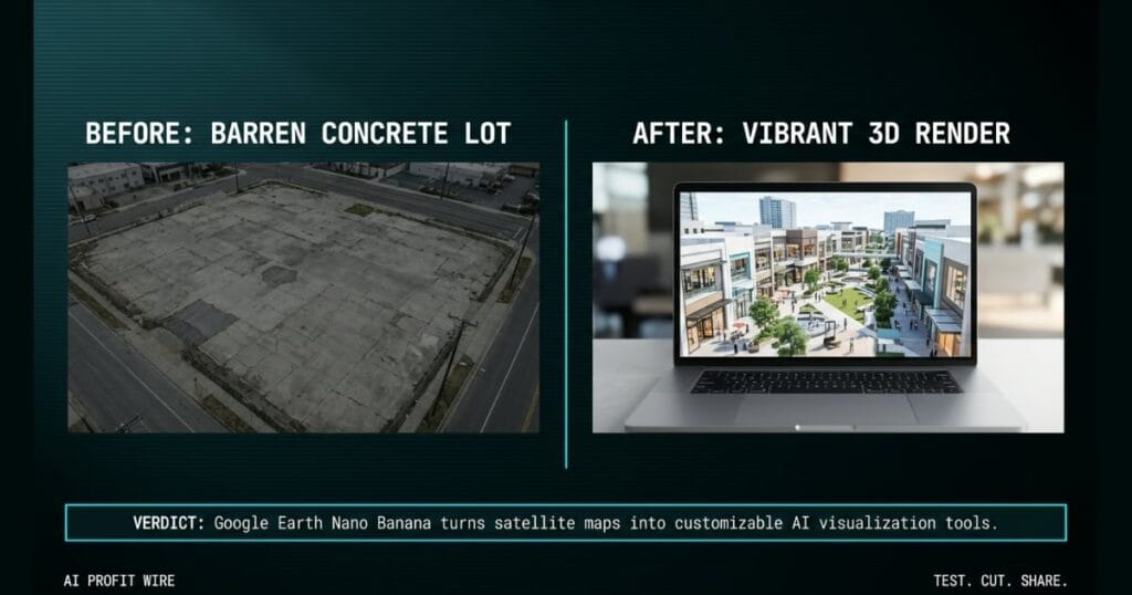
Real estate agents, architects, and urban planners can save time and money on 3D renderings by instantly visualizing and pitching project concepts to clients.
What’s Google Earth Nano Banana and what changed?
Google Earth now integrates Nano Banana to generate custom AI images of any location. Users can visualize historical concepts or future real estate plans directly on the map.
You can zoom in to a specific place on the web, tap “create image,” and type a prompt to see a photorealistic rendering. This transforms an empty lot into a visual concept in seconds.
The feature grounds the generated concepts in the real world using existing satellite, aerial, and 3D imagery. Google’s announcement lists 5 specific ways to use the tool, from history to real estate to home design.
Google Earth Nano Banana turns satellite maps into customizable AI visualization tools.
What’s the evidence behind Google Earth Nano Banana?
The official Google AI Blog confirms the feature is available globally today for web users. The launch announcement provides 5 specific examples of how the tool functions in practice.
Users can render a hyper-realistic view of the Pompeii ruins from 78 A.D. or generate an infographic with key historical facts. Gemini retrieves the relevant information while Nano Banana creates the graphic in seconds.
For real estate, architects can type a prompt to reimagine an empty lot in Tokyo as a vibrant shopping and retail district with open spaces. The tool instantly replaces the barren concrete with a high-quality 3D rendering of a bright urban oasis.
The evidence shows Google Earth Nano Banana instantly generates grounded, custom visual assets from text prompts.
How does Google Earth Nano Banana compare to the alternatives, and what background do small business owners need?
Google Earth Nano Banana operates directly within a web browser, generating custom images without leaving Google Earth. Users type a prompt and the tool handles the visual rendering.
Architects and urban planners can bring their plans to life by typing a prompt. The tool lets clients visualize the final result through a single sentence.
It provides an immediate visual concept for client presentations, grounded in actual satellite and 3D imagery rather than a blank canvas.
Google Earth Nano Banana trades engineering precision for instant visual concept generation grounded in real satellite data.
How does Google Earth Nano Banana affect day-to-day operations for small businesses?
Real estate agents, architects, and urban planners can save time on external 3D renderings. You can instantly visualize and pitch project concepts to clients.
The tool allows you to visualize projects before breaking ground, whether you’re planning a new backyard studio or a lakeside dream home. It provides immediate visual context for initial concept art.
You can generate a modern lakefront cabin built from sustainably sourced local materials nestled perfectly in the actual landscape. For more signals on how founders use breaking AI tools to lower operational costs, scan the full archive.
Small business owners use Google Earth Nano Banana to cut concept design time and accelerate client approvals.
The 6am open at the brewery means checking the fermentation tanks and prepping the tasting room for the weekend crowd. You just signed a lease on an adjacent lot to build a beer garden, and your investors need to see the vision by noon.
You open Google Earth on your laptop, zoom into the empty gravel lot, and type a prompt for a vibrant outdoor space. Within seconds, Nano Banana replaces the barren concrete with a photorealistic rendering of patio seating and open green space, using Google Earth’s existing satellite and 3D imagery.
You send the image to your investors, lock in the funding, and get back to checking the tanks. The tool handles the heavy visual lifting, which lets you focus on the actual operational execution of the expansion. It’s not a blueprint, but it closes the imagination gap in seconds.
What’s the final verdict on Google Earth Nano Banana?
Google Earth Nano Banana is a highly practical tool for small business owners who need fast visual concepts. It shortcuts initial pitches with photorealistic visuals in seconds.
The global web availability means you can access it today without installing new software. It grounds your ideas in real-world satellite imagery, which provides immediate context for your clients.
The tool delivers high-quality, photorealistic renderings in seconds based entirely on your text prompts. It’s a direct operational upgrade for anyone pitching physical spaces.
Google Earth Nano Banana is an essential visualization tool for accelerating physical project pitches.
Source: Google AI Blog
